
Key facts
Start here
LEI MapCreate Canada 6.3 Topo Addendum I Map Coverage by CD
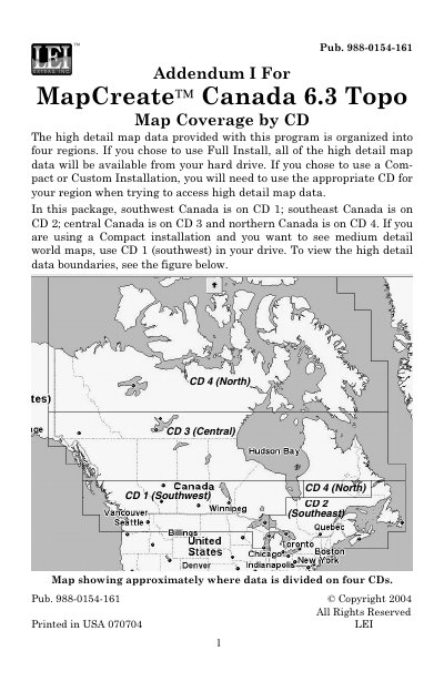
This document serves as Addendum I for the LEI MapCreate Canada 6.3 Topo software, specifically outlining the map coverage provided by the accompanying CD set. It explains how high detail map data is organized into four distinct regions: southwest, southeast, central, and northern Canada.
The text clarifies installation requirements, noting that users with a Full Install have all data on their hard drive, while those using Compact or Custom Installations must use the appropriate CD for their region to access high detail data. It specifies which CD corresponds to which region and provides a visual guide for data boundaries.
LEI MapCreate Canada 6.3 specifications
| Software Version | 6.3 |
|---|---|
| Number of CDs | 4 |
| Region 1 | Southwest Canada |
| Region 2 | Southeast Canada |
| Region 3 | Central Canada |
| Region 4 | Northern Canada |
Source: LEI MapCreate Canada 6.3 Topo Addendum I Map Coverage by CD
All LEI MapCreate Canada 6.3 documents by type
Questions answered in these manuals
Which CD contains the high detail map data for southwest Canada?
The high detail map data for southwest Canada is located on CD 1.
From: LEI MapCreate Canada 6.3 Topo Addendum I Map Coverage by CD
What should I do if I chose a Compact or Custom Installation?
You will need to use the appropriate CD for your region when trying to access high detail map data.
From: LEI MapCreate Canada 6.3 Topo Addendum I Map Coverage by CD
What regions are covered by the high detail map data in this package?
The high detail map data is organized into two regions: northern Canada and southern Canada.
Which CD should be used to access high detail map data for northern Canada?
You must use the Canada-North (disc 1) CD to access high detail map data for northern Canada.